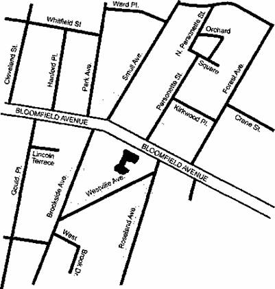
Directions
First Presbyterian Church at Caldwell
326 Bloomfield Avenue
Caldwell, NJ 07006
We are located on Bloomfield Avenue, at the intersection of Roseland Avenue and Westville Avenue, in Caldwell Borough, Essex County, New Jersey.
From Upstate New York: Take New York State Thruway to exit 14A and Garden State Parkway south. Stay on Garden State Parkway for 15 miles to exit 159 and Route 80 West. Follow directions for “Route 80 West”.
From George Washington Bridge: Cross Bridge and follow signs for Route 80 West. Follow directions for “Route 80 West”.
From Route 80 West: Take Exit 52 for “Lincoln Park/Fairfield/The Caldwells.” At the end of the ramp bear right onto Lane Road. Go to the end, turn right onto Two Bridges Road. Follow for 3.4 miles (Two Bridges Road turns into Passaic Avenue, CR-613). Turn left onto Bloomfield Avenue east (CR-506) (two Shell stations at intersection). Follow Bloomfield Avenue for 1.3 miles to the intersection of Roseland Avenue, and the Church is on the right.
From Route 80 East: Take Exit 47B for Route 46 East (It will also say “Montclair” on the exit sign). Follow directions for “46 East”
From Route 287: Exit onto Route 80 East, Exit 37A. Follow the directions from “80 East”.
From Route 46 East: Follow sign for “Caldwell.” Bear right at the New York/Caldwell fork onto Bloomfield Avenue east (Rental Center on right). Go eight lights on Bloomfield Avenue to the corner of Bloomfield and Roseland Avenues – the Church is on the corner, on the right.
From Garden State Parkway North or South: Go to Exit 145 to Route 280 West to Exit 5B (“The Caldwells”). Ramp puts you on North Livingston Avenue – take to end. At light turn right onto Eagle Rock Avenue. Go 200 yards – turn left at Shell Station onto Roseland Avenue – take to end. Caldwell Presbyterian Church on left corner.
Parking
Parking is available at the following locations, all easily accessible and within 600′ of the church:
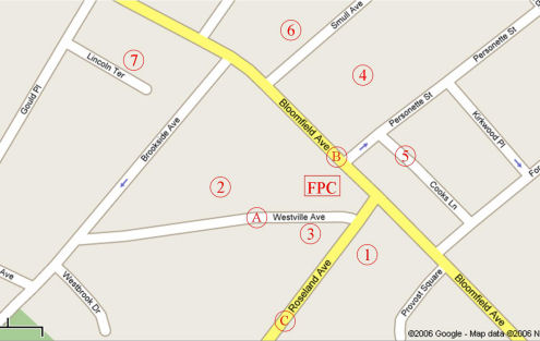
On-Street Parking:
A. Westville Avenue
B. Bloomfield Avenue
C. Roseland Avenue
Parking Lots:
- Roseland Avenue municipal covered parking garage, lower level entrance on Roseland Avenue (avoid permit & fire department spots), and upper level entrance on Provost Square behind Caldwell Library.
- Westville Avenue municipal lot just west of church. (entrances on Westville Ave. & Bloomfield Ave. next to diner)
- Westville Avenue private lot behind Valley National Bank. (do not block ATM) (Sunday morning only)
- Municipal lot behind Valley National Bank on Bloomfield Ave. (do not block ATM), entrances from Personette Street and Smull Avenue.
- Municipal lot along Cooks Lane behind American Legion, between Personette Street and Forest Avenue.
- Smull Avenue private lot adjacent to Dancy Funeral Home. (Sunday morning only)
- Municipal lot off Lincoln Terrace, behind Jack’s Foodtown Supermarket, entrance via Gould Place.
Map
Download and print this parking map and take it to go!